Showing posts with label Day Hike. Show all posts

Monday, July 21, 2014

Mt. Damas and the Ubod Falls

Three months of not indulging in any activities is kind a boring. I was burn-out! So, I decided to join my friend’s mountain climbing. And, this time we are heading to North Luzon. Our goal is to reach the peak of Mt. Damas.

So, let’s see what this mountain can offers…

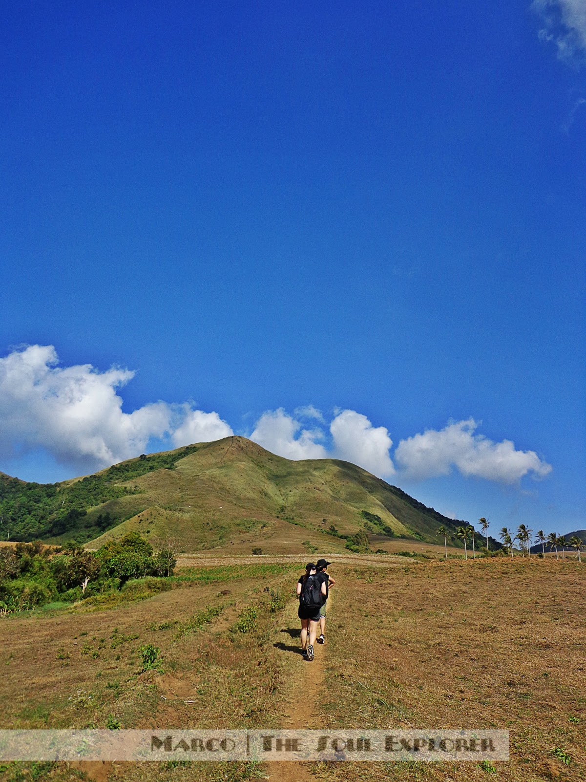
Mt. Damas is 685 MASL, located in San Clemente, Tarlac. Sitio Dueg is the major jump-off, while the alternate jump-off is in Brgy. Papaac, Camiling, Tarlac. And, have difficulty of 6/9. As a matter of fact, this is very challenging especially when having a flash flood. This mountain is small, but more challenging because it requires you to river crossing, river trekking and rock climbing in order to reach the foot of Mt. Damas.

At the peak, the landscape is superb; one can experience a panoramic view of the Tarlac and neighbouring mountains.
view of Mt. Damas from Brgy. Papaac
At exactly six o’clock in the morning, our trek started. The trail is undoubtedly not so difficult, but when we finally get to the river the challenge has begun. It was a long river trek. According to our guide, it will take two hours before we reach to the foot of the mountain. This part of the trail was rocky. And, you have to climb the rock to descend on the falls going to the base. From the river, you can see the mountain already and yet it still requires more hours to reach the peak.
almost on the top...
The group just enjoys the trail, rock climbing, and river crossing. If I can still remember, we did a rock climbing five times. Then, we arrived at the foot of the mountain after two hours and just have a quick brunch.

Now, we enter the thick vegetation and thorny vines going up to the summit. From the foot of Mt. Damas, the trail is becoming steeper and steeper. I just trying to assist myself not to get cramps because it’s really an unending assault! It takes two hours to reach the summit. Another challenging part is to descend here.
From the base, trekking again going to the Si-El Falls and we will get jumped to the water, but the guide recommended the Ubod Falls because it’s bigger. So, we trekked our way to the Ubod Falls. And, again we need to climb mini falls to get to the Ubod Falls.
the highest point
We took photos first and then, getting ourselves ready to jump to the water to feel fresh and relax from very tiring descent! But, when the rain is heavily pouring we immediately pack up our things and leave the area to avoid the flash flood. We have difficulty in descending and climbing because the rock is slipper. However, we arrived safely!
Ubod Falls

It is another great experience in the north!

Itinerary
11:00 PM – meet up at Bus Terminal in Cubao
12:00 AM – ETD Cubao Terminal
03:00 AM – ETA Camiling, Tarlac
04:00 AM - early breakfast, the guide pick-up time (tricycle)
05:00 AM – arrived at Brgy. Papaac, preparation
06:00 AM – start trek
06:30 AM – river trek/crossing and rock climbing
08: 00 AM – arrived at the foot of the mountain
08:30 AM – start climb, assault
10:30 AM – summit
11:00 AM – descent
01:00 PM – arrived foot of the mountain, lunch
01:30 PM – explore water falls, Si-el Falls and Ubod Falls
02:30 PM – back to trail, river crossing, rock climbing
04:30 PM – Brgy. Papaac, clean up
05:00 PM – back to Camiling Tarlac, snacks
06:00 PM – ETD Manila

Important Notes

  • Wear gloves to protect your hands because you hold on to thorny plants as the steep going to the river.
  •  Bring skin protection because the sun protection from jump off to grassland may hit your skin.
  • There are lots of water source, so one to two liters of water is safe.
  •  There’s a flashflood when it rain; so bring a rope with you.
  •  And the most important is ENJOY! 

   How to go to Mount Damas
      From Cubao, ride a bus (Solid North bus) bound to Camiling, Tarlac
      Ride a jeep/tricycle from Camiling going to Brgy. Papaac, meet the guide

  Contact Person:
     Emman – 0908 942 3592

  Expenses:
    Cubao to Camiling – 265 php
    Trike – 100 php each
    Guide Fee – 500 php

Friday, January 3, 2014

Mt. Gulugod Baboy (525+) Adventure

What’s the best thing to do in holiday season? As for adventurer, the best thing to do in a holiday season is to travel or to complete what’s in the bucket list before the year 2013 ends. For us, we had our Christmas mountain climbing before we celebrate Christmas day.  This is not definitely the last mountain for this year because we also plan to do our year-end hike. There are options where to climb, but fortunately, we all agreed to climb a mountain in Anilao.

Mt. Gulugod Baboy, is officially my 10th conquered mountain, is located in Anilao, Mabini, Batangas, Philippines. It is a minor climb that requires half-day and one to two hours to summit. There are three peaks in the range; the first one is about 470 MASL, the second peak is about 485 MASL, and the highest peak is about 525 MASL.

From Southeast to Northwest are Gulugod Baboy (Peak 1), Gitna (Peak 2), and Pinagbanderahan (Peak 3). At the peak, from east to west; you can see the Janao Bay, Maricaban Island and Sombrero Islands are visible. The east side, you can see the city and the port of Batangas. The mountains of Lobo, Mt. Maculot, Mt. Batulao, and the Tagaytay highlands are also noticeable too!

My group decided to meet at the Bus Terminal in Buendia and we rode a bus bound to Batangas City. From Batangas Grand Terminal, we hired a jeep going to Mabini then drop-off at Philpan Diving Resort, and register. We start trek around ten thirty in the morning, it was already hot. And, we reached at the summit by twelve noon and had lunch then, took some pictures.

We’ve met Mr. Herman from Belguim and we are amazed by his energy. He was biking from the jump off up to the summit. And, we totally admire him as he discussed the place you can see around the mountain and everything. He knows what you can see from Southeast to Northwest and from East to West. We just like, Wow! Amazing man!
the famous tree

Pastoral view
Do you remember teletubbies land?  Yes, the mountain is looked like a teletubbies land.  At the peak, the clouds are not totally clear during that day, but we still amazed the beauty of the nature. However, we just witness the romantic view of the sunset when we descent. What I like this adventure is that the trail is very easy because you are just going straightforward until you have reached the peak of the mountain. Locals are very helpful, you can ask them.
the romantic sunset 
ITINERARY:
07:30AM – Meet up, Buendia Bus Terminal
08:00AM – Ride a bus bound to Batangas City, 157php
10:30AM – Batangas Grand Terminal, rent a jeep going to Mabini,
11:30AM - jump-off Philpan Diving Resort, register
11:35AM – start trek
12:35PM – Gulugod baboy (Peak 1)
01:00PM – Gitna (Peak 2)
01:30PM – Pinagbanderahan (Peak 3), Lunch
03:00PM – descent
04:30PM – clean up and refresh
05:00PM - back to Batangas Terminal
06:30PM – back to Manila

EXPENSES:
Bus – 157php
Rent a Jeepney – 130php (14pax)

And this is my official 10th conquered mountain! Hooray!

Until next climb,
Marco

Friday, December 13, 2013

Conquered Mt. Banoi

The last mountain I climbed was Mt. Kalisungan with 760 MASL. It was my 8th official mountaineering together with my friends. I stop climbing a mountain for almost three months because I am busy for my commitments. But, one day my friend Jeff invited me to join him to climb along with Ian, our mountaineer friend. Since I missed mountain climbing, without any hesitation I accepted the invitation.

Mt. Banoi, my 9th conquered mountain, is 850 MASL for the Two Towers Peak and about 960 MASL for the Main Peak, is located in the town of Lobo, Batangas, and is part of the mountain range that surrounds in the town. This is a minor climb and it’s about two to five hours of reaching the summit.

The first time we attempted to climb Mt. Banoi is failed because we are not able to reach the summit. From Sitio Malabnig, according to the local, is one to two hour trekking before you can reach the summit depending on how fast your pace is. And, take note, we arrived at Sitio Malabnig at two o’clock in the afternoon. Very late! So, we’re not able to make it. We just stay there for a while and we go back to the town because we need to catch up for the last trip going to Batangas that is five o’clock in the afternoon.

On our second attempt, we need to accomplish our mission, to reach the summit. Only Jeff and Ian are available on this day. This time, we arrived early in the town of Lobo. We rode a tricycle and asked the driver to drop-off at the Chapel.

You will begin your trek at the end of the road of Brgy. Balatbat, landmark is the Chapel. And, from there, about one and half an hour you will reach the major jump-off at Sitio Malabnig –is a community with dozen of houses and I salute to people living on the top of 400 MASL. 

The trail, actually, is not really confusing because it is mostly straightforward and you can ask the locals along the way, they are very helpful! You can also ask the people in the Sitio Malabnig the right way going to the Mt. Banoi. You can reach the first peak in 1.5 hours to two hours; it is easily identified because of the communication tower. The mountain features the scene of animal farm, villages, and the whole town of Lobo. Mt. Lobo, Mt. Daguldol, and Mt. Naguiling can be seen in the east.

We arrived at the first peak of the mountain during lunchtime and we decided not to pursue on the Main Peak instead of having a good lunch on the first peak. However, the views from the mountain are the same all the way through the peaks. It’s really up to you to visit the Main Peak. But, for us, we didn’t pursue to the Main Peak and we just stay and took our lunch. Then, descent.


Mt. Banoi Itinerary:
04:30 AM – meet up in Buendia, Pasay
05:00 AM – board bus bound to Batangas Grand Terminal, 157php
06:40 AM – arrive at Grand Terminal, ride jeepney going to Balagtas, 12php
07:15 AM – from Balagtas, ride a jeepney to Lobo Terminal, 8php
07:30 AM – board jeepney going to Lobo Town
08:50 AM – arrive at Lobo Town, register at police station, and ride a tricycle to jump-off (chapel)
09:00 AM – start trekking
10:00 AM – arrive at Sitio Malabnig
12:00 NN – first peak, Two Towers Peak, lunch
01:00 PM – descent
02:00 PM – Sitio Malabnig
03:30 PM – back to the Chapel, ride trike back to Lobo town (NOTE: get the contact number of the tricycle driver so he can pick you back to the town)
04:00 PM – clean up, ride a jeepney back to Batangas City
05:30 PM – Grand Terminal, back to Manila

Expenses:
Transportation: 500php
Food: 200php

And this is my 9th conquered mountain. Hooray!

Happy climbing! :)
Marco

Thursday, July 11, 2013

Mt. Kalisungan, 760+ (Dayhike)

After the unforgettable island adventure (see previous post), the group planned for another weekend getaway and settled to climb a mountain. Where we heading? 

There are lots of choices but the group agreed to climb Mt. Kalisungan – is the one of the smaller mountains in the Southern Tagalog region however, it is also one of the mountains that border the Banahaw Trilogy. It is located in Calauan, Laguna.

There are fruit trees all the way to Mt. Kalisungan – from rambutan, kaimito to sunkest, and buko which offer trail food but of course, don’t forget to ask permission before picking up the fruits. 

Also, there are coconut trees, banana plantations, and huge grasslands going to the peak of the mountain.


The view to the North side of the mountain is the Talim Island which Mt. Tagapo has been seen. To the east, the view of the highlands of Caliraya appears. Of course, the seven lakes of San Pablo verge by the two mountains Mt. Cristobal and Mt. Banahaw. To the west of the mountain, Mt. Makiling has been seen.

I met Jepoy and Badong at the HM Transport bus Cubao station and board a bus going to Sta. Cruz, Laguna. We dropped at the Duck Junction but guys make sure that you told Manong Conductor to drop you at the Victoria, Laguna (Duck Junction) so you don’t get lost. From there, we met Roy (our friend) and took a jeep bound to San Pablo and dropped at Brgy. Lamot 2 then, registered at Brgy. Hall and look for Mang Bino or his wife. This time, his wife is our guide (Ate Mercy, I am not sure of the name. I really forgot her name. Sorry!)


There are two locals offered to us a fresh buko while we’re on the trail and yes, we didn’t refuse the offer because we are also craving to it. Then, after few minutes we start trekking again. It’s sunny day during our hike and the heat of the sun burn your skin. We, also, brought plenty of water because as per review there are no water sources along the way and the heat makes you dehydrated.

We’re on the summit of Mt. Kalisungan at exactly 12 o’clock in the afternoon and feeling blessed because the clouds are so clear. We took pictures and make chitchat with the guide. Then, we go back to the downward slope. After the hike, we ate our late lunch at the nearest market.

ITINERARY
5:30AM – Assembly at HM Transport Bus Station, Cubao.
6:00AM – Board HM Transport bus bound to Sta. Cruz, Laguna (117.25php).
8:00AM – Get off at Victoria, Laguna (at the Duck Junction to be exact). You can take breakfast or buy food here. Take a jeep going to San Pablo and get off to Brgy. Lamot 2 (12-15php).
8:30AM – Register at Brgy. Hall, and look for a guide (10php-registration fee and 400php for the guide).
9:00AM – start trekking
12:00NN – SUMMIT
12:30PM – Lunch, Rest, Take photos….
1:30PM – descent
3:00PM – back to Manila

EXPENSES: 700php
How to get there:

  •   Take HM Transport bus bound to Sta. Cruz, Laguna, EDSA-Cubao. Ask the Manong Conductor to drop you off at Duck Junction in Victoria, Laguna.
  • From Duck Junction, take a jeep bound to San Pablo and drop off at Brgy. Lamot 2. Then, register at the Brgy. Hall and look for a guide. Contact number of Mang Bino is (+63-909-297-1437.
gAnd I officially declared that Mt. Kalisungan is my 8th conquered mountain. Hooray!

HHappy climbing,
Marco
g

Saturday, May 11, 2013

Reaching the Peak of Mt. Sembrano (745+)

Mt. Sembrano is 745 MASL and the trail is a bit challenging because there will be a rough road that leads to a rocky path. You might encounter locals that would offer to get  a fresh coconut juice for only 10 pesos. There are many Mango trees at the beginning of the trail. At the summit, the view is scenic, the view of Laguna Lake, Talim Island, Mt. Makiling are also seen while you are in the summit. 

Hiking, yes, is a challenge to yourself but  it is also a fulfillment to your life because  when you get into the peak of the mountain. It will make you say, SUCCESS! I DID IT! One of my hobby is mountaineering. I climb together
with my co-mountaineers yet I never tried major hiking but hoping that this year we will be having our major hike, crossed-fingers.

The last mountains we climbed was Mt. Talamitam and Mt. Batulao, on December 2012. We did a twin hike as we say goodbye 2012 and I climbed six mountain already for that year, not enough! After three months, finally, my first hike for this year happened and this is my official seventh mountaineering. 

On March 31, 2013 my group headed to the town of Rizal to conquer Mt. Sembrano. Of course, I am with my mountaineer friends Jeff and Ian. We also welcomed Art and Shan, and the three girls in our group; Kristel, Jane and Vienne.

The meeting place was at Starmall – Mandaluyong City, we supposed to met up at exactly five in the morning but the others are not on time. So, we left at six thirty in the morning bound to Tanay Market. It was two hours ride going to Tanay, Rizal. I have time to take a nap because I only have three hours of sleep that day. Arrived at Tanay Market around eight thirty in the morning, we immediately rode a jeep bound to Pililia, Rizal. We dropped off at Brgy. Hall of Malaya, Pililia, Rizal and registered our name and pay for 20 pesos for the registration fee.
South Peak, SUMMIT
We start trekking around ten in the morning and its already late. Our estimated time to start the trek was eight in the morning but since our trip is a bit long drive we just have to be patient and just enjoy while in the ride. We arrived at the campsite around ten-thirty in the morning. We rested in the campsite and a local young boy offered us a fresh coconut juice. Then, we begun to wander again going up to the North Peak or the so-called Low Peak – is the first high point. Thirty minutes away from North Peak, is the South Peak or the so-called Summit. 
Laguna Lake, from the summit of Mt. Sembrano
ITINERARY
6:00AM - Assembly, Starmall - Crossing
6:30AM – Take a jeep/van going to Tanay, Rizal
8:30AM – ETA Tanay Market (take a jeep bound to Malaya, Pililia)
9:30AM – ETA Brgy. Malaya, Pililia, Rizal (jump-off)
10:00AM – start trek
10:30AM – ETA Campsite
11:30AM – ETA North Peak (Low Peak)
12:00NN – SUMMIT, lunch
12:30PM – Start descent
02:00PM – Campsite, rest
03:30PM – back to jump-off, clean-up, then take a jeep back to Tanay/Manila
07:30PM – ETA Manila

And that made my official 7th conquered mountain! Hooray!

Happy climbing,
Marco

Sunday, January 6, 2013

Double Hike 2: Mt. Talamitam and Mt. Batulao

Last day of 2012 was really an adventure, we planned it before Christmas. My friends and I were having a last twin hike for 2012. We invited some friends and officemates to join our trip. Unfortunately, some are not available because they’re going to spend their Christmas in their hometown. And some are joining us.

December 30, 2012, we met at Pasay Rotonda. We rode a bus bound to Nasugbu, Batangas. We’re going to meet up Jin's officemates at Sitio Bayabasan. It takes 2 hours going to Nasugbu so I have time to take some nap.


We arrived at Sitio Bayabasan around 8:50am and we met the others then proceed to the registration, we paid for 20pesos each. Then, start trek.


Mt. Talamitam, 630+ meters above sea level, is a bald mountain and it was named after the Talamitam trees that used to raise on its hills. It was an easy trail going up to the peak of Mt. Talamitam. But, I would tell you that it can be a exhausting hike especially when the sun is already up. There are few trees cover.

It takes 1-2 hours to complete the trek up to the peak of the mountain. The trail is easy it starts at the end of a uneven road fall to Talamitam river and pass by a short woodland trek that connect to a grassland hills. The summit assault is about 30 minutes. At the summit, there are beautiful views especially if the sky is clear. Going back will take less than an hour.

-->
conquering Mt. Talamitam in a sunny day
The second mountain is Mt. Batulao, the two officemates of my friend will not joining us anymore to Mt. Batulao. But, our friend Roy will join us. We met him at Evercrest, Nasugbu. From there, we ate our lunch and took some rest. Then, proceed to the trek at exactly 2:00pm. We rode a tricycle going to the jump-off. We paid 10pesos each to the driver.

We didn’t hire a guide because this is our second time hike with Jin excluding Roy and Jey. We took the old trail to new trail. You can read my first hike in Mt. Batulao.
Mt. Batulao, the second time around

at the peak of Mt. Batulao
Itinerary of twin hike: Mt. Talamitam and Mt. Batulao

6:00am - assembly at Pasay Rotonda
6:30am - ride a bus bound to Nasugbu, Batangas. Just tell the driver/condutor to drop you at Sitio Bayabas.
8:50am - arrived at Sitio Bayabasan
9:00am - registration 20pesos each, then proceed to the jump-off and start trek
11:00am - Summit
11:30am - back to trail
12:00nn - Lunch and rest
1:45pm - from evercrest, ride a tricycle going to the jump-off
2:00pm - start trek (old trail), at campsite 1, register your name/group, pay 20pesos each
4:00pm - Summit
4:30pm - descent (new trail)
6:30pm - back to Manila

Sunset from Mt. Batulao
Cost
Bus fare - 124pesos/pax

Mt. Talamitam:
Registration Fee - 20pesos/pax
Tour Guide - 400pesos (we paid 400pesos to the guide)

Mt. Batulao:
Tricycle (evercrest to jumpoff) - 10pesos/pax
Registration Fee (Old Trail, campsite 1) - 20pesos/pax
Registration Fee (New Trail) - 20pesos/pax

**we didn't ride a jeep from Sitio Bayabasan to Evercrest because Jin's officemate offer us  to give us a drive. So, I guess, its minimum fare.


Estimated cost: 700pesos

Mt. Talamitam is my official 6th conquered mountain and second time to climbed Mt. Batulao. Hooray!

Happy climbing,
Marco

Saturday, September 8, 2012

The Adventure | Mt. Batulao (811 MASL)

With my co-soul explorer at the peak of Mt. Batulao
Batangas is a first class province of the Philippines, located on the southwestern part of Luzon. It has a combination of plains and mountains. One of these mountains is Mt. Batulao with 811 MASL, the name “Batulao” is from the tagalog word of “Bato sa Ilaw” (light in a rock).

Tuesday, August 21, 2012

Day Hike: Reaching the Highest Point of Mt. Tagapo (438 MASL)

My  friends and I are planning to climb a mountain nearby Metro Manila. But this past few weeks are so disappointing because the weather did not permit us to do so. Bad weather hits in the Metro that caused flood in some areas and some provinces close to Metro Manila. So, we have no choice but to cancelled the plan.

But it happened this week, we climbed to hit the highest point of Mt. Tagapo.

Related Posts Plugin for WordPress, Blogger...